Official websites use .gov
A .gov website belongs to an official government organization in the United States.

Secure .gov websites use HTTPS
A lock ( ) or https:// means you’ve safely connected to the .gov website. Share sensitive information only on official, secure websites.

Laurel Wilt

Scientific Name

Raffaelea lauricola sp. nov. T.C. Harr. Fraedrich & Aghayeva (Harrington et al. 2008)

Common Name

Laurel wilt (LW)

Native To

Probably Asia (the disease vector, the redbay ambrosia beetle (Xyleborus glabratus), is native to Asia) (Harrington et al. 2008)

Date of U.S. Introduction

Redbay ambrosia beetle first discovered in 2002; disease first discovered in 2003 (Fraedrich et al. 2007)

Means of Introduction

Probably arrived with the redbay ambrosia beetle on imported wood packing materials (Harrington et al. 2008)

Impact

Fungal disease of redbay (Persea borbonia) and other trees in the laurel family (Lauraceae) (Harrington et al. 2008)

Current U.S. Distribution

Southeastern U.S.

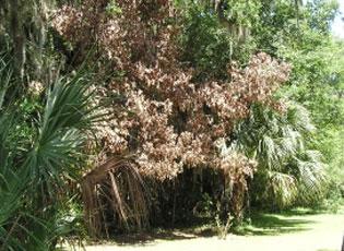
Laurel wilt damage - Invasive.org
Image use policy

Laurel Bay Damage, host Redbay

Credit

James Johnson Georgia Forestry Commission

Spotlights

  • Pest Alert: Laurel Wilt

    • Aug 2025
    • USDA. FS. Southern Region. State and Private Forestry.

    • Laurel wilt is a disease of woody plants in the laurel family (Lauraceae). Hundreds of millions of redbay (Persea borbonia) trees have been killed by laurel wilt in the southeastern Atlantic Coastal Plain region of the United States (US). The disease has also killed large numbers of sassafras (Sassafras albidum) trees in forests and landscapes, and avocado (Persea americana) trees in commercial production. As of October 2019, laurel wilt was known to occur from Texas to North Carolina, south through Florida and north to Kentucky. Laurel wilt is expected to continue spreading through sassafras in the eastern US, and is a potential threat to California bay laurel (Umbellularia californica) in the western US and to lauraceous species elsewhere in the world.
      See also: Region 8 - Forest Health for more information.

  • Laurel Wilt: Current and Potential Impacts and Possibilities for Prevention and Management

    • Jan 2021
    • USDA. FS. Southern Region.

    • "Laurel wilt, caused by the pathogen Raffaelea lauricola (T.C. Harr., Fraedrich and Aghayeva) and the primary vector, the redbay ambrosia beetle (Xyleborus glabratus Eichhoff), is a nonnative pest-disease complex first reported in the southeastern United States in 2002. Since then, it has spread across eleven southeastern states to date, killing hundreds of millions of trees in the plant family Lauraceae." This Review "examine[s] the impacts of laurel wilt on selected vulnerable Lauraceae in the United States and discuss[es] management methods for limiting geographic expansion and reducing impact."

Distribution / Maps / Survey Status

  • Alien Forest Pest Explorer (AFPE)

    • USDA. FS. Northern Research Station.

    • The Alien Forest Pest Explorer (AFPE) is an interactive web tool which provides detailed spatial data describing pest distributions and host inventory estimates for damaging, non-indigenous forest insect and disease pathogens currently established in the U.S. The database is maintained as a joint effort of Purdue University, the U.S. Forest Service Northern Research Station, and the U.S. Forest Service Forest Health Protection.

  • Distribution of Counties with Laurel Wilt Disease by Year of Initial Detection

    • USDA. FS. Forest Health Protection. Southern Region.

    • View the updated regional infestation map for Laurel Wilt Disease (for initial detection in May 2002. Map is updated periodically (USDA, FS - Forest Health).  Select "Counties Infected By Year" tab.

  • Early Detection & Distribution Mapping System (EDDMapS) - Laurel Wilt

    • University of Georgia. Center for Invasive Species and Ecosystem Health.

    • Provides state, county, point and GIS data. Maps can be downloaded and shared.

  • Laurel Wilt Progression Map

  • Laurel Wilt Public Dashboard Story Map

    • USDA. Forest Service; Georgia Forestry Commission.

    • The Laurel Wilt Public Dashboard story map – a collaboration between the Georgia Forestry Commission, multiple branches of the Forest Service, and other state forestry agencies – shows the annual spread of the disease. The story map shows that new detections occur mostly in the Coastal Plain, not in the Appalachian mountains where sassafras reaches its greatest sizes.

Videos

Selected Resources

The section below contains highly relevant resources for this species, organized by source.

Partnership
State and Local Government
Academic
Citations